The 'in-the-ground' Tour
October, 2010
[my favorite shots]
'Hole in the Ground' and 'Crack in the Ground' are unique features in Central Oregon. Though I had heard of both since I was a kid, I've never seen either one, nor have I ever met anyone that has been to either. While this might give you some clues as to the general entertainment of either of these features, I actually found them both to be quite fascinating.
Hole in the Ground is an explosion crater created when magma welling up from the depths came in contact with the local water table. The water flashed to steam and blew the covering soil and rock off, leaving a crater 500 feet deep and a mile in diameter. Talk about your 'big bang!' Rocks the size of houses were tossed a couple of miles.
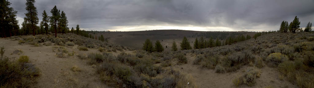
Hole in the Ground can be accessed via 3 miles of Forest Service dirt road off Highway 30, 25 miles southeast from La Pine, Oregon. A small sign points the way from the highway, easy to miss if you're not already looking for it. As luck would have it, this gem of Oregon geology is right on your way to -
Crack in the Ground is literally that - a crack in the ground a mile long and up to 70 feet deep. It is not for the faint of heart. There is no escape. You can't just decide you're done and climb out. The sheer basalt walls will see to that. Fortunately, the longest distance between access points is about 1,000 feet, so you'll probably survive. The crack is an old feature, historically speaking, and fortunately isn't likely to close up on you. Some clues to its origin might be found in the adjacent lava bed to the north.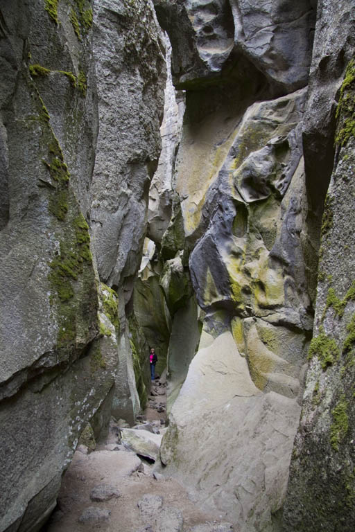
Crack in the ground is found 8 or 10 miles of dirt road due north of Christmas Valley, again marked by a small sign. Amenities include a decent parking area bordered by large boulders, a composting toilet, nice gravel pathways and a sign-in sheet. Only a dozen or so people had visited in the past week.
Those two features made the trip for me, but to keep the rest of the family entertained, we stopped at other sights along the way - Here's the complete itinerary in chronological order:
More than enough to keep even the most cynical tourist interested, in my mind.
Lacking a forest service map of the region between Crack in the Ground and Pine Mountain, I turned to Google Maps and Google Earth. The first thing I discovered was a totally undifferentiated spider's web of roads in the area. With Google Maps it wasn't possible to tell the main roads from barely passable tracks. The photographic nature of Google Earth made it a little easier - if you could see two distinct ruts, you could assume it was less of a major thoroughfare than one that appeared to have a more maintained surface.
The second challenge was distinguishing farm roads on private land from the main line into the National Forest. On that count I was just lucky. I happened to guess at a route that took us pretty much directly to the forest service region. It just so happened that when we encountered our first closed gate there was a local person there that told us private land owners are obligated to allow passage through their property to access Forest Service land. True or not, it got us where we wanted to go. But, I digress...
After studying the maze for a while I began in Google Earth, adding placemarks at what appeared to be intersections, including a comment of which direction to turn. If you have Google Earth installed on your computer you can open this file and see the results: in_the_ground_2010.kmz
Next, I spent an hour looking for ways to export this information in a format that I could use to import into my GPS. No luck. So, I created this 'escape plan' on paper - you can ignore the entries entitled 'bypass'. The first turn on the so-called bypass was impassable - Deep sand and a rock ledge that pitched us up 20 degrees to the right. Yes, I could have gone off road, but I'm not certain that would be the thing to do on private property. So, ignore the bypass. I'm sure it would have been an interesting, if not primitive route. escape_plan.rtf
With my escape plan in hand, I began entering the information into my GPS by hand. I decided to use a program on my iPhone called MotionX GPS. It has several features that were ideal for this trip -
I don't generally promote products on my website but this one is an exceptional value, in my opinion, priced at a reasonable $2.99. MotionX GPS
Anyway, here is the output from the GPS on our trip. These unedited, straight out of the application files. When not in the car actively driving I would put my iPhone in my pocket and the program continued to record, obtaining very accurate locations of photographs. Again, Google Earth is required, but it's a free program and you should already have it, anyway!
You may notice a little off route excursion just north of Crack in the Ground - I think I miskeyed a waypoint and we were headed off on a very primitive track to parts unknown. It's probably worth the trouble to double check your data entry... although it was rather interesting scenery.
One word of caution - GPS applications drive the phone very hard and can exhaust the battery in an hour or two of continuous use. I kept the GPS plugged in charging continuously while driving in order to capture a continuous record of a days travel. If you're out hiking, etc away from power for more than a couple of hours you can expect your phone to be dead before you get it back on the charger.